
 Anchor Alarm
Settings reference
The Settings tab gathers every preference plus your installed regions and
the data-sources page.
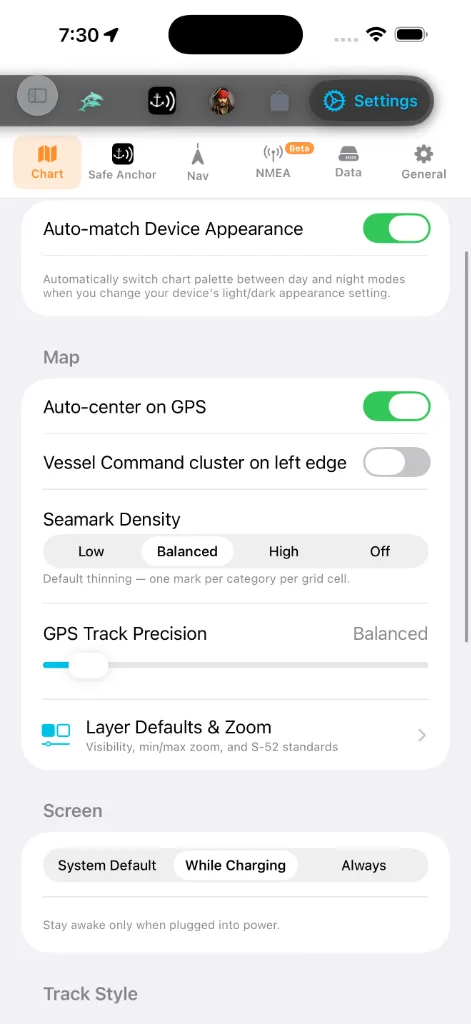
A segmented bar across the top splits the screen into six tabs so you can
jump straight to the family of preferences you want instead of scrolling:
centre, command-cluster edge, seamark density, GPS track precision, Layer
Defaults & Zoom), screen-wake policy, track style, tile-fetching engine.
alarm sound + test, GPS tracking mode, power consumption, Backup & Sync,
privacy, Help & Manuals, and the About card with your live build number).
route parameters, waypoint options, voyage / TSS alarms, the shallow-water
alarm, live GPS status, and Simulator Mode.
Wi-Fi gateway, or a Bluetooth pod, plus live diagnostics.
remote services (e.g. NHC tropical cyclones with a Test connection button).
Backup & Sync is not here — it lives under the Safe Anchor tab.
preset + per-quantity overrides), app language, and the About card.
Sections within each tab, in the order you see them:
Chart Appearance
The Chart tab's only appearance control is one toggle:
between its day and night variants automatically as your device's
light/dark appearance setting changes. Turn it off to keep whichever
palette you picked regardless of the system theme.
The base map style and the depth color palette are not set here.
They live in the in-chart Chart Layers → Maps panel — open the chart,
tap the layers control, and pick from the day/night map and palette grids.
See Chart layers.
Units & Measurement
Lives under the General tab. Two layers:
quantity at once to a coherent system. Maritime convention is preserved
in every preset: distance defaults to nautical miles and speed to knots.
pickers when you need to override the preset: Depth, Distance,
Short distance, Speed, Wave height, Air temperature,
Water temperature, Pressure, Vessel dimensions, Anchor
rode / chain, Volume, and Coordinates.
Every other tab and overlay follows these settings.
App Language
screens are written in. The app ships 13 languages: English, Türkçe,
Deutsch, Français, Italiano, Español, Ελληνικά, Hrvatski, Português,
Svenska, Norsk bokmål, Dansk, and Suomi. Each is listed in its own script so
you can spot your language even when the current one is unfamiliar.
to override it just inside AnchorQueen.
screens only switch to the new language on the next launch. Number, date, and
unit formatting update immediately.
Navigation
you prefer. Tap the row to open the Tab Order editor, then hold the
handle on the right of any tab and drag it up or down. The tab bar
updates the moment you lift your finger. Tap Reset in the top-right
corner to restore the factory order. Your arrangement is saved
automatically and survives app restarts. See
saves a point. Shorter is more detailed; longer is smaller files.
Vessel Profile
> Set up from your boat card. The first time you save a boat card, the
> app fills this screen in from it: your LOA is converted from the
> length you entered, and draft, beam and safety margin start as those of a
> typical boat that size and type. Your length is your own figure — the
> draft is not, and two boats of the same length can differ by more than a
> metre. Check the draft here before relying on depth warnings, route
> planning or anchoring advice. Once you change anything on this screen the
values are yours, and the app never overwrites them again.
Under the Nav tab. These four numbers describe the hull itself, and they
are the ones the rest of the app measures water against.
50ft, Sailboat 55ft) to fill all four fields at once. Change any field
afterwards and the picker reads Custom. A preset replaces the dimensions
only — your boat's name, hull type, cruise speed and pin colour are kept.
chart and how far the anchor swing circle reaches beyond
the rode.
squat and tidal uncertainty.
planning refuses anything shallower, and soundings below it paint red on
the chart.
for every ETA in the app, but only until AnchorQueen has watched you sail:
once you have finished three or more passages, the app uses your measured
average speed over the last twelve of them instead, because what the boat
actually does beats what was typed once. A route always keeps its own speed
override, so a delivery under motor does not rewrite your average. If you
have never set a cruise speed, the app falls back to a sensible figure for
your hull type, and to 6 knots if it knows nothing at all.
There is no save step. Each field is stored the moment you change it, and
one set of numbers feeds every consumer: route planning, sounding colours, the
shallow-water alarm below, your boat's icon, and anchor swing. If you use
Backup & Sync, edits travel to your other devices with everything else.
Depth Grid on the same section is status, not a setting — it names the
chart region currently loaded for depth-aware routing, or reads Not loaded
when you have no region installed for where you are.
Safety Alarms
Under the Nav tab, alongside the voyage alarms:
against the flow, or anchor inside a
Traffic Separation Scheme (COLREGS Rule 10). On by
default; advisory cases raise an amber banner, violations a red one.
too little water under your keel. Uses your boat's draft from the
[Vessel Profile](#vessel-profile) on this same tab. This alarm is visual
only — a red on-screen banner, no sound. *(Moved here from the Safe Anchor
tab.)*
alarm fires. When the alarm is sounding you can Silence (30 m) it, then
Resume before that window ends.
Screen
while AnchorQueen is open. A navigation app is useless if the chart
goes dark mid-passage, so AnchorQueen lets you opt out of the standard
auto-lock without changing your device-wide setting.
external power. This is the default: ideal for a phone or iPad
cradled on a 12 V outlet at the helm, while a handheld in your
pocket still sleeps.
foreground. Best for long legs where the device is permanently
powered; expect heavier battery drain otherwise.
Backgrounding the app always restores normal sleep behaviour, so the
device can rest between sessions regardless of which mode you pick.
Track Style
Under the Chart tab, below Screen Wake. A live preview at the top
of the section redraws as you change any control, so you can see the result
before you leave Settings.
line shades from slow to fast along the track).
colour ramp across each passage's own min–max speed; Fixed uses a
constant 0–12 kn scale so colours mean the same speed on every track.
recent run stands out.
Auto-record passages at sea *(also on the Chart tab, in the Map
section)* — one switch for every kind of automatic recording. On by
default: AnchorQueen records automatically when you're underway — on a
planned voyage or free sailing — and saves the passage when you anchor or
go ashore. Turn it off and recording is yours alone, on the REC button.
This replaces the separate Auto-record voyages switch of earlier
versions; the two asked you to tell a "voyage" from a "passage", which is
not a distinction the app makes anywhere else. If you had deliberately
turned the old switch off, the merged one starts off too. See
Tile Engine
Under the Chart tab, at the bottom. Picks how chart tiles are fetched:
→ network cache, using pre-downloaded offline tiles when available. The
right choice for offline use.
built-in HTTP engine, with no offline cache support.
A caption under the picker spells out the trade-off for whichever engine is
selected.
AIS Traffic
Under the Chart tab, below Tile Engine. Read-only — it tells you how live
ship traffic is reaching this iPhone right now. You don't choose this; the app
does, per session, and it can change while you're under way.
aisstream.io, shared by the whole fleet, so this iPhone doesn't open one of
its own. This is the best case: one connection serves everybody instead of
one per device.
exactly as it always has, but it uses the key built into the app, which every
copy of AnchorQueen shares.
stored, so you have three connections nobody else is sharing. See
connections are all taken. Adding a key of your own fixes it immediately.
aisstream.io account allows are in use: another device on the same key, or
a connection that dropped without closing and that the service has not
released yet. Close AnchorQueen on your other devices and try again in a
while.
Layers.
The shared connection needs you to be signed in. Signed out, AnchorQueen
uses the direct connection instead — live traffic keeps working either way, and
you never have to do anything about it. If the shared connection is unavailable
for any reason, the app falls back on its own and the ships keep coming.
Waypoint Naming
your saved marks read like "Turtle Cove" instead of coordinates.
Cluster behavior
bottom-left for thumb-friendly one-handed use.
Installed Regions
A list of every chart region you have installed,
grouped by cruising ground — Mediterranean, Northern Europe, United States,
Mexico, Caribbean, Pacific, East Asia, Worldwide. The groups, their order, and
the country flags on each row match the Store → Charts
catalog, so a pack sits under the same heading wherever you look at it. Each
row shows:
Get More Regions at the bottom jumps to the
Browse Region Data (also at the bottom of the regions area) opens a
low-level inspector for the installed data — region manifests, NavGrid
files, and MBTiles metadata. Double-tap any file to inspect it. It's a
diagnostic surface; you don't need it for everyday use.
Safe Anchor (Anchor Watch Settings)
The Safe Anchor tab now hosts the full Anchor Watch settings inline —
no longer a separate sheet. From top to bottom: the Launch section (see
below), Permissions status, the
alarm sound + alarm test, the GPS tracking mode (Real Time vs.
Moving Average) and Power Consumption (Balanced vs. Highest),
Backup & Sync (see [#backup](#backup)), the Privacy section (see
[#privacy](#privacy)), Help & Manuals, and the About card. See
SafeAnchor for what each does.
button that opens iOS Settings. The card closes with a standing reminder
that continued use of GPS running in the background can dramatically
decrease battery life: AnchorQueen keeps the GPS awake only while an anchor
watch, voyage recording, or active navigation is running.
Radar screen — the classic anchor alarm —
every time it starts. Handy if you use AnchorQueen primarily as an anchor
alarm. This wins over the tab you were last on: with the setting off,
the app resumes wherever you left it (see
where the app opens); with it on, every
launch is Radar. (When an anchor watch was armed at your last session,
the app returns to SafeAnchor regardless of this setting.)
the 5-second countdown lock the phone and switch it to silent (or turn
on a Focus). The test alarm must still sound — that is the
Critical Alert doing its job. If it stays silent,
enable iOS Settings → Notifications → AnchorQueen → Critical Alerts.
Run this once before trusting the watch overnight.
Privacy
Two opt-out switches, both on by default, both effective immediately —
no restart, no sign-in required:
the fault can be found and fixed.
for: which tabs you open, whether an anchor watch was armed and for how
long, whether a route solved, whether a chart download finished. Never
your position, your boat, your name, your messages to Jules, or anything
you typed. Continuous numbers (a swing radius, a passage length) are
reported as ranges, not exact values.
Turning Usage Analytics off stops collection and clears the
identifiers already stored on the device. Nothing in the app behaves
differently with either switch off — no feature is gated on them.
Your device's own record. The first time you do something the app has to
remember — arm an anchor watch, open the Store — it creates an anonymous
record for this device so that usage can be counted without knowing who you
are. It holds the app version, your device model, your language and the
plan you are on. It never holds your position, your boat, your name or your
email. If you later create an account, that record simply becomes yours, so
nothing you did beforehand is lost. With Usage Analytics off, the record
is never created at all.
Manual link, both opening in your browser.
installed version and build number — quote these to support), and, where
ad consent is required (mainly EEA/UK), a Manage Ad Consent button that
reopens the consent dialog so you can change your choice.
The shallow-water alarm now lives under the [Nav](#navigation) tab (see
[Safety Alarms](#safety-alarms)), and the Instruments data source moved to
its own [NMEA](#instruments) sub-tab.
Simulator Mode
Override your real GPS with a position you drop on the chart — useful for
demos, planning a passage from the dock, or testing the anchor watch
without leaving the marina.
panel docks at the bottom of the chart.
on the right-edge controls). It drops the simulated vessel at the chart
centre instantly when that point is over water; over land it asks you to
centre on water first. Tap SIM again (it glows orange while active) to
end the simulation.
you left it after any movement) is restored the next time you enable
Simulator Mode. When off, each session starts fresh at the map centre.
On the chart a helm console docks at the bottom. Your boat appears with
its name and symbol, drawn to its real length the same way AIS
traffic is — so a large vessel reads bigger than a small one and scales
with zoom (dimensions come from your vessel profile).
The console lets you:
then tap to place the vessel there.
slider. The boat eases up to speed like a real hull rather than jumping.
round at a realistic rate), Steady holds the current heading,
Reverse comes about, To compass steers the way the device points,
All stop brings her to a halt.
the passage unfold. Turn it off to pan freely.
Simulator Mode off in Settings → Nav.
Tap the console header to collapse it to a compact autopilot strip —
a big course-to-steer with −10 / −1 / +1 / +10 port (red) and starboard
(green) keys for one-handed course tweaks while sailing. Tap it again to
re-open the full helm.
> Simulator Mode replaces your position everywhere — the chart, the GPS
> HUD, track recording, and the anchor watch all follow the simulated boat.
> Your compass heading stays real — only the position is faked. Turn it
off to return to live GPS.
NMEA — Instruments
The NMEA sub-tab (marked Beta in the segmented bar) is the instrument
data source. By default AnchorQueen reads your position from the device's
Built-in GPS. If your boat has NMEA instruments, point the app at them here
to get masthead wind, a depth sounder, and a fixed-mount GPS.
needed; the right choice for most phones and tablets.
gateway that broadcasts NMEA sentences.
the SafeAnchor guide for the full walkthrough.
192.168.4.1) and Port (default 10110; Signal K servers use 3000).
advertising themselves on the boat network, or type the host and port. Try
Test Server connects to the public demo server immediately so you can see
the link working with no boat hardware.
Signal K Position (use the server's own-vessel fix as the chart and
SafeAnchor live position), Use TLS (wss) (leave off for a boat-network
server), and Access Token for a server with security switched on.
Signal K Position is off by default. When enabled, device GPS automatically
resumes if the server delivers no valid position for 30 seconds.
your pod in the list to select it. Bluetooth instruments share no
common standard, so just pick your device and Apply.
dropout. Shown for the NMEA sources only.
Wind, and the last NMEA sentence so you can confirm data is flowing.
depth (labelled with what it is measured from), wind with its angle and
whether it is true or apparent, speed through water, sea temperature, and
how long ago the last update arrived. These update as the data arrives.
can see what went wrong without a computer aboard.
> NMEA data needs a Wi-Fi gateway, Bluetooth pod, or Signal K server on your
boat. With none of those, keep Built-in GPS.
For model-specific addresses, ports, capability limits, and setup steps, see
Connect boat instruments. The compatibility table on
that page distinguishes what works in this release from direct local AIS and
automatic equipment discovery that are still planned.
Backup & Sync
> Where to find it: Backup & Sync is a row under the Safe Anchor
> tab (in its Data section), not under the Settings Data tab.
Open Safe Anchor → Backup & Sync to reach the controls below.
Keep your captain marks, routes, and boat profile safe and consistent
across devices.
across every device signed in to the same account. Shows the sync
status (Synced · time, Syncing…, or an error) with a Sync Now
button for an immediate push.
file is AES-encrypted and the same passphrase is required to
restore it. Leave it empty for an unencrypted backup.
save off-device.
data: marks and routes are added or updated, never deleted.
Data Sources & Partners
A read-only sheet listing every provider whose data feeds the app —
OpenStreetMap and MapLibre, ESRI and Mapbox, NOAA and national met
services, Wikipedia, Global Fishing Watch, and others — with links to each
provider's website.
Services
Advanced diagnostics. The most useful is the NHC connection test which
checks whether the National Hurricane Center cyclone feed is reachable.
Help — the manual and release notes
Under the General tab, above the About card, are two entries into the
documentation that ships with the app. Both work with no connection.
same way this book is (Start here, The tabs, Reference, *Release
notes*), and a search field that looks inside every page and takes you
to the exact section, not just the page.
From there, Earlier releases lists the notes for every previous version
the app knows about, so you can catch up after skipping an update. The
version you have installed is marked Installed.
The manual is translated into the same languages as the app. If a page has
not been translated yet, it is shown in English with a note saying so — the
manual never hides a page because a translation is missing. The language
follows your [App Language](#language) setting.
The same manual is reachable from the sidebar — see
You do not have to come here after an update: the release notes for a new
version open by themselves on the first launch after it installs, once — see
About card
AnchorQueen shows version information in two places:
version and build number. Quote this when you contact support.
static label), Map Data (OpenStreetMap), Mode (GPS Only ·
Offline), and Map Engine (MapLibre GL). It does not track your build
number; use the Safe Anchor card for that.
Your Cached Tiles size is shown separately, under the Data tab's
Storage section; it is calculated in the background and reads
"Calculating…" briefly on first load.
If something goes wrong
chart refreshes labels on next draw.
(switch sub-modes once) and try again.
Safer sync and backups
This device’s local library stays linked to its first signed-in account after the update. Signing in to another account pauses library sync; sign back in to the owning account to resume. Offline records stay on the device. New encrypted backups use stronger password protection and remain readable in 2.4.4 or later; older backups can still be restored. Backup processing runs in the background, with a 128 MiB file limit. Cross-device passage deletion and out-and-back track preservation have also been corrected.