Grundläggande gränssnitt — ramen kring varje skärm
Några få kontroller svävar ovanför varje flik. Lär dig dem en gång så fungerar
de överallt.
Flikfältet
Nio flikar låter dig byta yta:
den inledande kanten.
Varje flik känns igen på en ikon — ankare för SafeAnchor, delfin för
Merconi, pixeloctopus för Jules, kugghjul för Inställningar och så
vidare. Tryck på valfri flik för att byta.
En sidofältsväxel (ikonen sidebar.left) upptill öppnar eller döljer en
meny som listar alla flikar med fullständiga namn — användbart innan du har
memorerat ikonerna. En sök-funktion öppnar
[Kommandopaletten](#command-palette). På iPhone i stående läge sitter
sökknappen inbäddad i det övre flikfältet, direkt före SeaTracker-pillret —
så att nå sökningen och sjökortet är en enda gest. I liggande läge är det
ett förstoringsglas högst upp på sidoremsan.
En liten bricka på fliken Butik visar hur många av dina installerade
regioner som har uppdateringar som väntar.
Menyn i sidopanelen (liggande och iPad)
I liggande läge (och på iPad) öppnar kartan en storleksjusterbar
sidopanel vid den högra kanten. Där bor menyn inuti den panelen som dess
startskärm — den separata vänsterlådan och dess växel visas inte, eftersom
panelen redan ger menyn en permanent plats med betydligt mer utrymme. När du
trycker på en funktion på sjökortet (en hamn, ett fartyg, en teckenförklaring)
glider dess detaljer in över menyn; Tillbaka för dig åter till menyn. Fäll
ihop panelen med chevronen för att återta hela kartan; den smala listen som blir
kvar öppnar den igen.
I stående läge på iPhone, och på iPad i stående läge, finns ingen
sidopanel, så menyn stannar i den välbekanta vänsterlådan som öppnas av
växeln sidebar.left som beskrivs ovan.
Ruttplanering och Simulator dockas också här
I liggande läge flyttar paneler som annars skulle täcka botten av sjökortet
in i samma högra sidopanel, så att kartan hålls fri:
djup-/vind-/våg-/farts-graferna och ruttåtgärderna) fyller sidopanelen i
stället för ett bottenblad. Menyn är dold medan du planerar och återkommer när
du lämnar Ruttläget eller minimerar panelen.
simulatorn körs.
I stående läge visas båda fortfarande som dragbara bottenblad över sjökortet.
Sidofältets sidhuvud
Överst i sidofältet finns några snabblänkar ovanför fliklistan:
din kaptensprofil.
hoppar till Butikens prenumerationer.
dig (och underrubriken speglar öppna konversationer), och tryck leder rakt in
i tråden. Öppnar det inbyggda feedbackflödet där du kan rapportera ett fel
eller begära en funktion, bifoga en skärmdump och följa statusen för allt du
har skickat in (Öppen / Pågår / Löst / Stängd) — med teamets svar och dina
egna uppföljningar i en enda tråd. Samma skärm nås från menyn
SafeAnchor → Radar — se
Live Discover — vad du har samlat
På kartflikarna öppnas sidofältet med ett avsnitt LIVE DISCOVER. Allteftersom
du panorerar sjökortet hämtar AnchorQueen nautiska objekt från onlinetjänster —
fyrar, bojar, sjömärken, hamnar och marinor, ankarplatser, faror, landmärken och
vrak — och behåller dem medan du rör dig.
Varje rad visar två siffror, t.ex. Fyrar · 400 · +45:
appen startade; objekt som redan cachelagrats från en tidigare körning räknas
inte).
Ett +N-chip bredvid det pulserande LIVE DISCOVER-sidhuvudet summerar
sessionssumman över varje kategori — din "samlat hittills"-räkning.
Tryck på en rads +N-bricka för att öppna listan med just de nyligen samlade
objekten, sorterade efter avstånd. Tryck på valfri post för att se dess
fullständiga detaljer eller svep för att spara den som en waypoint.
(AIS-fartygsraden visar bara en liveräkning — fartyg kommer och går, så det finns
ingen sessionssumma.)
Ändra ordning på flikarna
Du kan placera flikarna i vilken ordning du vill:
position.
Tryck på Återställ i det övre högra hörnet när som helst för att återställa
den ursprungliga ordningen. Din uppställning sparas automatiskt och överlever att
appen stängs.
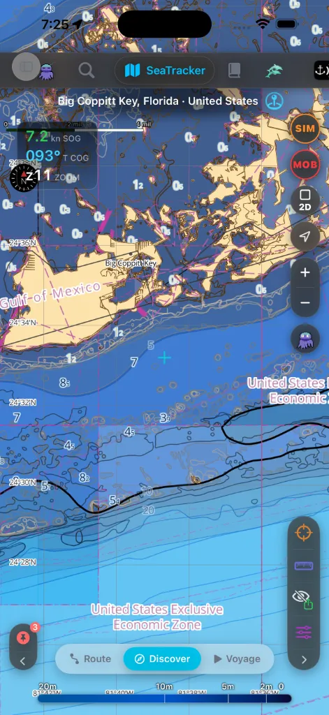
Det övre sidhuvudet (kartflikar)
På de tre kartflikarna (SeaTracker, Capt's Notebook, Merconi) rider
ett smalt sidhuvud över sjökortet med flikens namn, en brödsmulestig till din
aktuella plats och snabbåtgärder för sjökortsstil och lager.
Kartkamerakontroller
På valfri kartflik sitter ett lodrätt kluster av glasknappar vid den avslutande
kanten, uppifrån och ner:
mittpunkt när den punkten ligger över vatten, så att du kan segla en låtsasbåt
därifrån; fylls orange medan Simulatorläget är aktivt, tryck igen för att
avsluta det.
båt.
lämna kartan.
zoomen.
GPS-spår; cirkeln blir helröd medan inspelning pågår.
eller, medan en rutt följs, stoppa den. Att trycka på STOPP ber dig
bekräfta först så att ett förlöpt rorkultstryck inte kan släppa vägledningen.
De flesta knappar visas bara där de gäller (Lägg till foto i Capt's Notebook,
REC i Resa, ruttens trio ADD / UNDO / DEL medan du placerar waypoints), så
kolumnen visar aldrig kontroller du inte kan använda.
Dataverktyg — hårkors, linjal, ren export och lager — bor i en separat
[Snabbåtgärdspanel](#clean-export) nere till höger, inte i den här kamerakolumnen.
Det finns ingen ljudavstängningskontroll på sjökortet.
MOB-knappen
MOB-knappen är den viktigaste kontrollen på sjökortet — en svartglascirkel
med röd kontur och en röd MOB-etikett, placerad mitt i klustret (precis under
Sök och SIM) så att den alltid ligger i samma tumräckvidd som zoom och centrera
om. Ett tryck:
Använd den i samma stund en person eller ett föremål går överbord. Den fungerar
på varje kartflik. Knappen gråtonas medan en man överbord-händelse redan är
aktiv, så att du inte kan utlösa en andra av misstag.
Hela returflödet — MOB-retur-HUD:en, hypotermibanderollen och utfallen
Verklig övning / Avbruten — dokumenteras i
GPS-HUD:en
Det mörkglasade HUD-kortet uppe till vänster på sjökortet visar dina
livepositionssiffror. Hopfällt staplar det tre avläsningar:
(för ankar → driver → marschfart → snabb) och fungerar dessutom som en tidig
signal om ankaravdrift: en ihållande långsam krypning gör den gulorange innan
det dedikerade larmet har tillräckligt delta för att utlösas.
z).Tryck på kortet för att expandera det. Det expanderade HUD:et lägger till:
Tryck länge på endera koordinatchipet för att kopiera det — menyn erbjuder de
marina formaten (DD / DDM / DMS), en geo:-URI, en Apple Maps-URL, en
AnchorQueen-länk och Dela…. Om du klistrar in en koordinat dyker ett piller
upp ovanför kortet med åtgärderna Flyg till och Lägg till WP.
På fliken SafeAnchor, där SOG och COG är brus för en ankrad båt, fälls kortet
ihop till bara zoomavläsningen.
Kommandopaletten
Sökfunktionen (se [flikfältet](#tab-bar)) öppnar en helskärms
Kommandopalett med två flikar som du växlar mellan upptill:
och dina sparade waypoints. Den behåller en SENASTE-historik som fungerar
offline, en åtgärd Rensa historik, och ett Jules-filterchip som visar
bara de sökningar Jules körde åt dig.
så att du kan hoppa rakt till en inställning utan att minnas vilken flik den
bor på.
Med rutan tom visar fliken Funktioner introduktionstips-funktionerna som en
inbyggd rundtur av vad appen kan göra.
Teckenförklaringspaneler
Varje sjökortslager kan öppna en teckenförklaringspanel med sina egna
växlar, och varje panel kan minimeras till en enda pillerknapp på
Regionknappfältet — en lodrät glaskapsel fäst nere till vänster på kartan
— så att du väljer vad du ser utan stök.
Fältet bär ett piller per aktiv kategori:
Det döljer automatiskt varje kategori vars antal i vyfönstret är noll, så att
tomma vatten inte stökar till listen; panorera tillbaka till befolkat vatten så
återkommer pillren. Tryck på ett piller för att se ett kategorinamns-verktygstips,
och fäll ihop hela fältet till en chevron när du vill ha kartans kant fri.
Undermodsfält (botten)
Flera flikar har ett frostat glaspillerfält nederst som visar flikens
undermoder:
Den valda undermoden är markerad. Tryck på ett piller för att byta omedelbart.
Snabbåtgärder och ren export
En separat glaspanel nere till höger på sjökortet rymmer dataverktygen (inte
kameraverktygen):
punkten.
Vissa sjökortsbilder behöver sparas utan appkrom ovanpå. Att trycka på Ren tar
bort flikfältet, sidofältet, teckenförklaringspanelerna och resten av överläggen,
och byter panelen till att visa två exportknappar: PDF och Bild.
Titelblocket och datakällsattributionen renderas in i den exporterade PDF:en
eller PNG:n — de är en del av den sparade filen, inte ett ständigt påslaget
överlägg du ser på skärmen. Tryck på Ren igen för att ta tillbaka kromet.
Om något går fel
stående och liggande läge lägger ut kromet olika. [Flikfältet](#tab-bar)
flyttas till sidan i liggande läge.
SeaTracker, Capt's Notebook eller Merconi för att använda den.