Merconi — Meereslebewesen und Ozean-Erkundung
Merconi ist AnchorQueens Erkundungsmodus: eine Seekarte, abgestimmt auf das lebendige
Meer — Tauchplätze, Sichtungen von Meereslebewesen, Ozeanbedingungen und
Fischereiaktivität.
Was sich ändert
Wenn Sie Merconi betreten:
dem Kartenstil ein, den Sie bereits verwendet haben — es erzwingt keinen eigenen
Stil. (Wenn Sie die türkise Tiefenpalette Reverse · Merconi Reef Guardian
möchten, wählen Sie sie selbst; siehe [Reef-Guardian-Palette](#reef-guardian).)
Meereslebewesen, Tauchplätze, Fischerei-Beobachtung und Ozeandaten, je nach Modus
umgeschaltet (siehe die Tabelle unten). Ihre ursprünglichen Layer-Schalter kehren
zurück, wenn Sie den Tab verlassen.
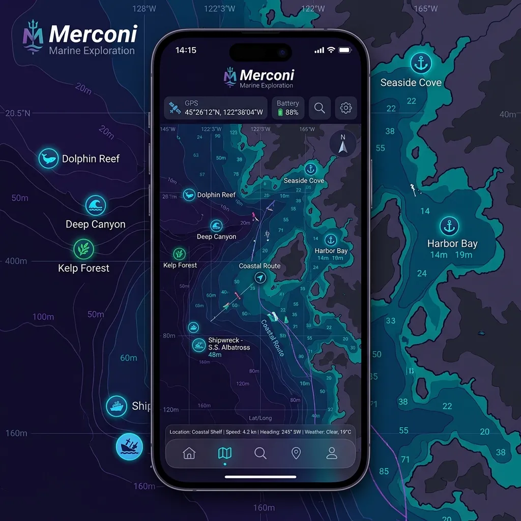
Tauchen — Entdecken — Fischen.
| Untermodus | Was auf der Karte ist |
|---|---|
| Tauchen | Vorkommens-Marken von Meereslebewesen + Tauchplätze |
| Entdecken (Standard) | Ozeandaten-Punkte + Artikelkapsel |
| Fischen | Aufwands-Heatmap von Global Fishing Watch |
Jeder Untermodus zeigt eine gezielte Auswahl an Layern, nicht alle vier auf einmal.
Tauchen
Eine taucherorientierte Voreinstellung, die Tauchplätze und Meereslebewesen-Marken
zeigt — Fischerei-Heatmaps und Ozeandaten-Punkte bleiben aus, damit die Karte
aufgeräumt ist. Nutzen Sie Tauchen, wenn Sie einen Schnorchelplatz erkunden oder einen
Tauchtag planen.
gemeldet wurde, und einen Link zum Quelldatensatz. Namen werden um landläufige
(volkstümliche) Namen angereichert und, wo bekannt, um ein IUCN-Schutzabzeichen —
siehe [woher diese Daten kommen](#technical-engine).
die Quelle hat, sehen Sie:
Wassertemperatur und Strömungsstärke.
und ein Website-Link.
einen Kapitänsmarken-Schalter.
nach Region — ein ruhiger Platz hat vielleicht nur einen Namen und Koordinaten.
Entdecken (Standard)
Der Merconi-Standard. Entdecken zeigt Ozeandaten-Punkte — Meeresbedingungen,
über die Karte verteilt abgetastet — neben der stets aktiven Artikelkapsel zur
Unterwassergeografie und Biodiversität. Meereslebewesen-Marken werden hier nicht
gezeigt; sie wohnen im [Tauchen](#diving).
Ozeangitter kommen vom Copernicus Marine Service — siehe [woher diese Daten
kommen](#technical-engine).
Fischen
Legt eine Global-Fishing-Watch-Aufwands-Heatmap über Ihre Karte.
bedeuten mehr Fischereistunden.
legt fest, wie weit zurück der Aufwand summiert wird — es ist kein
Schiffstyp-Filter.
Flaggenstaat (dem Land des Schiffes) gruppiert, mit einem Balkendiagramm aus
Stunden und Schiffen, nach Fischereistunden gereiht. Sie können die Zellen jedes
Flaggenstaats umfärben.
Ein-Tipp-Zoom-zu-Kacheln, wenn Sie außerhalb dieses Bereichs sind.
Boote arbeiten.
> Die Fischerei-Überlagerung benötigt einen kostenlosen Global-Fishing-Watch-API-Token,
> der in der App konfiguriert sein muss. Ohne einen zeigt das Panel einen Zustand
> „API-Schlüssel erforderlich“ und keine Heatmap — siehe [Falls etwas
schiefgeht](#if-something-goes-wrong).
Woher Merconis Daten kommen
Merconis Erkundungslayer sind live, vernetzte Dienste — sie fragen öffentliche
Meeresdatenbanken bei Bedarf ab und speichern die Ergebnisse pro Region auf der
Festplatte zwischen, sodass ein Platz, den Sie bereits angesehen haben, noch lädt,
wenn Sie offline sind. Keiner dieser Layer ist mitgeliefert oder auf dem Gerät
vorberechnet; ein leerer Layer bedeutet meist kein Netz oder keine Datensätze für
dieses Gebiet, nicht einen Fehler.
Meereslebewesen — OBIS + WoRMS
Arten-Vorkommens-Marken. AnchorQueen fragt die Live-OBIS-Web-API für Datensätze
innerhalb der sichtbaren Region ab (kein Konto nötig) und speichert jede Region auf
der Festplatte zwischen. Das Antippen einer Marke zeigt die Art, wo und wann sie
erfasst wurde, und einen Link zum Quelldatensatz.
(volkstümliche) Namen in vielen Sprachen, ein IUCN-Rote-Liste-Schutzabzeichen,
wo eines existiert, eine grobe Maximalgröße, ein Neozoen-/invasiv-Kennzeichen und —
für Fische — einen Link zu ihrer FishBase-Seite.
Fischerei-Aufwand — Global Fishing Watch
Der Untermodus Fischen legt eine kommerzielle Fischerei-Aufwands-Heatmap von
Global Fishing Watch (GFW) über die Karte, gerendert als Raster-(PNG-)Kacheln,
die direkt auf die Karte gestreamt werden — keine auf dem Gerät gezeichneten
Vektorkonturen. Der Aufwand wird über das von Ihnen gewählte Zeitfenster summiert und
nach dem Flaggenstaat (Land) des Schiffes aufgeschlüsselt. Dieser Layer erfordert
einen kostenlosen GFW-API-Token, der konfiguriert sein muss; ohne einen bleibt er
leer, und das Panel zeigt einen Hinweis „API-Schlüssel erforderlich“.
Ozeanbedingungen — Copernicus Marine Service
Der Ozeandaten-Layer von Entdecken streamt hochauflösende Ozeangitter vom
Copernicus Marine Service (CMEMS), bei Bedarf für das sichtbare Gebiet geholt. Das
zugrunde liegende Modell veröffentlicht 6-stündliche Zeitschritte (nicht
minutengenau), sodass sich die Werte in diesem Takt aktualisieren. Layer umfassen
Meeresoberflächentemperatur, Strömungen (Geschwindigkeit und Richtung) und verwandte
Felder, nützlich für Drift-Tauchen und Routenplanung.
Schritt-für-Schritt-Erkundungsführung
Einen Tauchtag planen
dass die signifikante Wellenhöhe unter Ihrer Sicherheitsreserve liegt und der Wind
ablandig ist.
Merconi-Untermodus-Leiste an, um Tauchplätze und Meereslebewesen-Marken über Ihrer
aktuellen Karte einzublenden. Für ein kontrastreiches bathymetrisches Aussehen
wählen Sie optional die Tiefenpalette Reverse · Merconi Reef Guardian selbst
im Kartenlayer-Panel — Merconi schaltet sie nie für Sie um.
(Tiefenbereich, Einstieg, Sicht, Wassertemp., Strömung) und etwaige
Tauchcenter-Kontaktdaten zu sehen.
sehen, welche Arten an diesen Koordinaten erfasst wurden.
Aktive Fischereizonen meiden
GFW-Token muss konfiguriert sein — siehe [Falls etwas schiefgeht](#if-something-goes-wrong)).
6M · 1J — um festzulegen, wie weit zurück der Aufwand summiert wird. Ein längeres
Fenster offenbart anhaltende Brennpunkte; Live zeigt nur die jüngste Aktivität.
geschäftigsten Fischereigebiete, um die Sie einen Bogen machen sollten — und prüfen
Sie die Aufschlüsselung pro Flaggenstaat unter der Karte, um zu sehen, welche
Flotten welcher Länder dort arbeiten.
Reef-Guardian-Palette
Reef Guardian ist eine türkis-cyanfarbene Tiefenpalette, keine Basiskarte und
nichts, was Merconi für Sie einschaltet. Wenn Sie sie möchten, öffnen Sie das
Kartenlayer-Panel und wählen Sie Reverse · Merconi Reef
Guardian im Tiefenpaletten-Wähler. Sie kombiniert die luminanzinvertierten Lotungen
mit hellem Flachwasser, was sich über küstennahen Tauchgebieten gut liest. Da es eine
normale Palettenwahl ist, bleibt sie bestehen, bis Sie sie zurückändern — in jedem
Tab, nicht nur in Merconi.
Tipps
Seegang machen einen echten Unterschied beim Tauchen oder Fischen.
sie als neugierigen Ausgangspunkt, nicht als Garantie.
Falls etwas schiefgeht
Fishing Watch benötigt einen kostenlosen API-Token, der in der App konfiguriert
ist. Bis einer hinzugefügt ist, kann der Aufwandslayer nicht laden; registrieren Sie
sich bei globalfishingwatch.org, um einen Token zu erhalten.
Zeitfenster (7T / 30T), prüfen Sie, ob Sie zwischen etwa Zoom 2 und 12 sind (nutzen
Sie den Zoom-zu-Kacheln-Knopf des Panels), und stellen Sie sicher, dass Sie eine
Netzwerkverbindung haben — die Kacheln streamen live.
Live-Dienste. Ohne Netzwerkverbindung kommen Regionen, die Sie zuvor nicht
besucht haben, leer zurück; eine bereits geladene Region wird aus dem Cache auf dem
Gerät bedient. Fahren Sie weiter oder zoomen Sie zurück zu einem
zwischengespeicherten Gebiet.
OpenStreetMap-Tauchplätze sind in manchen Gebieten dünner; zoomen Sie für Kontext
heraus.