Grundlegende Oberfläche — der Rahmen um jeden Bildschirm
Einige Bedienelemente schweben über jedem Tab. Lernen Sie sie einmal, und sie
funktionieren überall.
Die Tab-Leiste
Neun Tabs lassen Sie zwischen Oberflächen wechseln:
Spalte am vorderen Rand.
Jeder Tab ist an einem Symbol erkennbar — Anker für SafeAnchor, Delfin für
Merconi, Pixel-Krake für Jules, Zahnrad für Einstellungen und so weiter.
Tippen Sie einen Tab an, um zu wechseln.
Ein Seitenleisten-Umschalter (das Symbol sidebar.left) oben öffnet oder
verbirgt ein Menü, das alle Tabs mit ihren vollen Namen auflistet — nützlich, bevor
Sie die Symbole auswendig kennen. Eine Such-Funktion öffnet die
[Befehlspalette](#command-palette). Im Hochformat des iPhone sitzt der Suchknopf
direkt in der oberen Tab-Leiste, unmittelbar vor der SeaTracker-Pille —
sodass der Griff zur Suche und zur Seekarte eine Geste ist. Im Querformat ist
es eine Lupe oben am Seitenstreifen.
Ein kleines Abzeichen auf dem Tab Store zeigt, für wie viele Ihrer
installierten Regionen Updates anstehen.
Menü im Seitenpanel (Querformat & iPad)
Im Querformat (und auf dem iPad) öffnet die Seekarte ein größenveränderbares
Seitenpanel am rechten Rand. Dort lebt das Menü innerhalb dieses Panels als
dessen Startbildschirm — die separate linke Schublade und ihr Umschalter werden
nicht angezeigt, weil das Panel dem Menü bereits einen festen Platz mit weit mehr
Raum gibt. Wenn Sie eine Funktion auf der Seekarte antippen (einen Hafen, ein Schiff,
eine Legende), schiebt sich ihr Detail über das Menü; Zurück bringt Sie zum Menü.
Klappen Sie das Panel mit dem Pfeil zu, um die volle Karte zurückzugewinnen; die
dünne Leiste, die bleibt, öffnet es erneut.
Im Hochformat auf dem iPhone und auf dem iPad im Hochformat gibt es kein
Seitenpanel, daher bleibt das Menü in der vertrauten linken Schublade, die durch den
oben beschriebenen sidebar.left-Umschalter geöffnet wird.
Routenplanung & Simulator docken hier ebenfalls an
Im Querformat wandern Panels, die sonst den unteren Teil der Seekarte verdecken
würden, in dasselbe rechte Seitenpanel, damit die Karte frei bleibt:
die Tiefen-/Wind-/Wellen-/Geschwindigkeitsdiagramme und die Routenaktionen) füllt
das Seitenpanel statt eines unteren Blattes. Das Menü ist verborgen, während Sie
planen, und kehrt zurück, wenn Sie den Routenmodus verlassen oder das Panel minimieren.
der Simulator läuft.
Im Hochformat erscheinen beide weiterhin als ziehbare untere Blätter über der Seekarte.
Der Seitenleisten-Kopf
Oben in der Seitenleiste finden sich einige Schnellzugriffe über der Tab-Liste:
Kapitänsprofil zu öffnen.
den Abonnements im Store springt.
geantwortet hat (und der Untertitel spiegelt offene Unterhaltungen wider) und
springt direkt in den Verlauf. Öffnet den App-internen Feedback-Ablauf, in dem Sie
einen Fehler melden oder eine Funktion anfragen, einen Screenshot anhängen und den
Status all dessen verfolgen können, was Sie eingereicht haben (Offen / In
Bearbeitung / Gelöst / Geschlossen) — mit den Antworten des Teams und Ihren eigenen
Rückfragen in einem Verlauf. Derselbe Bildschirm ist über das Menü
SafeAnchor → Radar erreichbar — siehe
Live Discover — was Sie gesammelt haben
Auf den Karten-Tabs öffnet die Seitenleiste mit einem Bereich LIVE DISCOVER.
Während Sie die Seekarte schwenken, holt AnchorQueen nautische Objekte aus
Online-Diensten — Leuchtfeuer, Tonnen, Baken, Häfen & Marinas, Ankerplätze,
Gefahren, Landmarken und Wracks — und behält sie, während Sie weiterfahren.
Jede Zeile zeigt zwei Zahlen, z. B. Leuchtfeuer · 400 · +45:
gesammelt haben (seit dem App-Start; Objekte, die bereits aus einem früheren
Lauf zwischengespeichert sind, werden nicht gezählt).
Ein +N-Chip neben dem pulsierenden Kopf LIVE DISCOVER summiert den
Sitzungsgesamtwert über alle Kategorien — Ihre „bisher gesammelt“-Bilanz.
Tippen Sie auf das +N-Abzeichen einer Zeile, um die Liste nur dieser neu
gesammelten Objekte zu öffnen, nach Entfernung sortiert. Tippen Sie einen Eintrag
an, um sein vollständiges Detail zu sehen, oder wischen Sie, um ihn als Wegpunkt zu
speichern. (Die Zeile AIS-Schiffe zeigt nur einen Live-Zähler — Schiffe kommen und
gehen, also gibt es keine Sitzungsbilanz.)
Die Tabs neu anordnen
Sie können die Tabs in jede beliebige Reihenfolge bringen:
seine neue Position.
Tippen Sie jederzeit oben rechts auf Zurücksetzen, um die ursprüngliche
Reihenfolge wiederherzustellen. Ihre Anordnung wird automatisch gespeichert und
überdauert das Schließen der App.
Der obere Kopfbereich (Karten-Tabs)
Auf den drei Karten-Tabs (SeaTracker, Capt's Notebook, Merconi) reitet
ein schmaler Kopfbereich über der Seekarte mit dem Namen des Tabs, einer
Brotkrumenspur Ihres aktuellen Standorts und Schnellaktionen für Kartenstil und Layer.
Kamerasteuerung der Karte
Auf jedem Karten-Tab sitzt ein senkrechtes Bündel von Glasknöpfen am hinteren Rand,
von oben nach unten:
wenn dieser Punkt über Wasser liegt, sodass Sie von dort ein Geisterboot fahren
können; füllt sich orange, während der Simulatormodus aktiv ist, erneut tippen
beendet ihn.
Kamera auf Ihr Boot fixiert ist.
die Karte zu verlassen.
Kapitänsmarke setzen.
abschalten; der Kreis wird durchgehend rot, während aufgezeichnet wird.
oder, während eine Route befolgt wird, sie stoppen. Beim Tippen auf STOP
werden Sie zuerst um Bestätigung gebeten, damit ein versehentlicher Tipp am Ruder
die Führung nicht abbrechen kann.
Die meisten Knöpfe erscheinen nur dort, wo sie zutreffen (Foto hinzufügen in Capt's
Notebook, REC im Törn, das Routen-Trio ADD / UNDO / DEL, während Sie Wegpunkte
setzen), sodass die Spalte nie Bedienelemente zeigt, die Sie nicht nutzen können.
Datenwerkzeuge — Fadenkreuz, Lineal, Sauber-Export und Layer — leben in einem
separaten [QuickActions-Panel](#clean-export) unten rechts, nicht in dieser
Kameraspalte. Es gibt keine Audio-Stummschaltung auf der Seekarte.
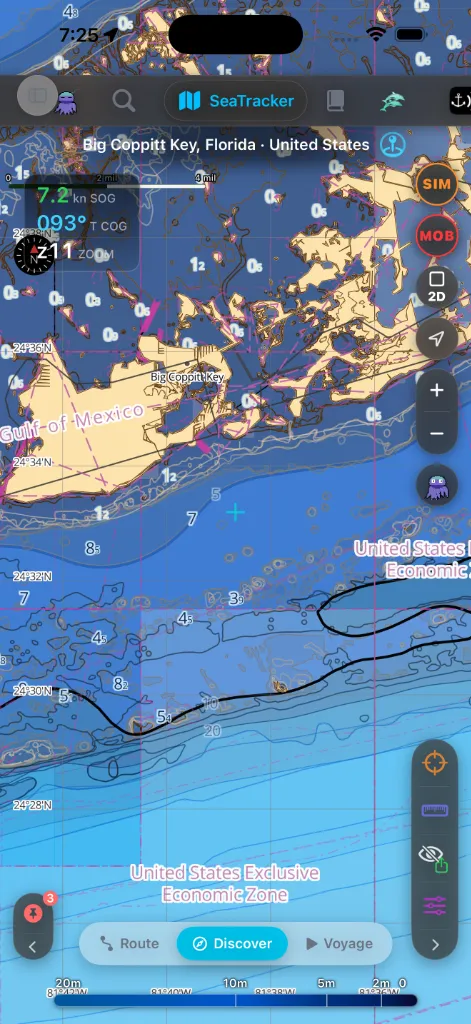
Der MOB-Knopf
Der MOB-Knopf ist das wichtigste Bedienelement auf der Seekarte — ein
schwarz-gläserner Kreis mit roter Umrandung und einer roten MOB-Beschriftung, in
der Mitte des Bündels sitzend (direkt unter Suche und SIM), sodass er stets im
gleichen Daumen-Reichweitenband wie Zoom und Neuzentrieren liegt. Ein Tipp:
Nutzen Sie ihn in dem Augenblick, in dem eine Person oder ein Gegenstand über Bord
geht. Er funktioniert auf jedem Karten-Tab. Der Knopf wird ausgegraut, während ein
Mann-über-Bord-Vorfall bereits aktiv ist, sodass Sie nicht versehentlich einen
zweiten auslösen können.
Der vollständige Rückführungs-Ablauf — das MOB-Rückführungs-HUD, das
Unterkühlungs-Banner und die Ergebnisse Echter Übungsfall / Abgebrochen — ist
unter SafeAnchor dokumentiert.
Das GPS-HUD
Die dunkel-gläserne HUD-Karte oben links auf der Seekarte zeigt Ihre
Live-Positionswerte. Eingeklappt stapelt sie drei Anzeigen:
sich mit der Geschwindigkeit (vor Anker → vertreibend → marschierend → schnell) und
dient als früher Hinweis auf Ankervertreiben: ein anhaltendes langsames Kriechen
färbt sie gelb, bevor der eigentliche Alarm genug Differenz zum Auslösen hat.
z).Tippen Sie auf die Karte, um sie aufzuklappen. Das aufgeklappte HUD ergänzt:
Halten Sie einen der Koordinaten-Chips lange gedrückt, um ihn zu kopieren — das
Menü bietet die maritimen Formate (DD / DDM / DMS), eine geo:-URI, eine
Apple-Karten-URL, einen AnchorQueen-Link und Teilen… an. Wenn Sie eine
Koordinate einfügen, erscheint über der Karte eine Pille mit den Aktionen Hinfliegen
und WP hinzufügen.
Auf dem Tab SafeAnchor, wo FüG und KüG für ein ankerndes Boot nur Rauschen sind,
klappt die Karte auf nur die Zoom-Anzeige zusammen.
Die Befehlspalette
Die Such-Funktion (siehe [die Tab-Leiste](#tab-bar)) öffnet eine bildschirmfüllende
Befehlspalette mit zwei Tabs, zwischen denen Sie oben wechseln:
und Ihre gespeicherten Wegpunkte hinweg. Sie führt einen VERLAUF, der offline
funktioniert, eine Aktion Verlauf löschen und einen Jules-Filter-Chip, der
nur die Suchen zeigt, die Jules für Sie ausgeführt hat.
Namen, sodass Sie direkt zu einer Einstellung springen können, ohne sich zu merken,
in welchem Tab sie wohnt.
Bei leerem Feld zeigt der Tab Funktionen die Onboarding-Hinweisfunktionen als
eine eingebaute Tour dessen, was die App kann.
Legendenpanels
Jeder Kartenlayer kann ein Legendenpanel mit eigenen Schaltern öffnen, und jedes
Panel lässt sich auf einen einzelnen Pillenknopf in der Regionsknopfleiste
minimieren — eine senkrechte Glaskapsel, die unten links auf der Karte angeheftet ist
— sodass Sie wählen, was Sie sehen, ohne Unordnung.
Die Leiste trägt eine Pille pro aktiver Kategorie:
Sie verbirgt automatisch jede Kategorie, deren Anzahl im sichtbaren Ausschnitt null
ist, sodass leere Gewässer die Leiste nicht überladen; schwenken Sie zurück zu
bevölkertem Wasser, und die Pillen erscheinen wieder. Tippen Sie eine Pille an, um
einen Kategorienamen-Tooltip zu sehen, und klappen Sie die ganze Leiste auf einen
Pfeil zusammen, wenn Sie den Kartenrand frei haben möchten.
Untermodus-Leisten (unten)
Mehrere Tabs haben unten eine Pillenleiste aus Milchglas, die die Untermodi des Tabs
zeigt:
Der gewählte Untermodus ist hervorgehoben. Tippen Sie eine Pille an, um sofort zu wechseln.
QuickActions & Sauber-Export
Ein separates Glaspanel unten rechts auf der Seekarte hält die Datenwerkzeuge
(nicht die Kamerawerkzeuge):
zu diesem Punkt anzeigt.
Manche Kartenaufnahmen müssen ohne darüberliegende App-Bedienelemente gespeichert
werden. Ein Tipp auf Sauber entfernt die Tab-Leiste, Seitenleiste,
Legendenpanels und den Rest der Überlagerungen und tauscht das Panel gegen zwei
Export-Knöpfe: PDF und Bild. Der Titelblock und die Datenquellennennung
werden in das exportierte PDF oder PNG gerendert — sie sind Teil der gespeicherten
Datei, nicht eine ständig sichtbare Überlagerung auf dem Bildschirm. Tippen Sie
erneut auf Sauber, um die Bedienelemente zurückzuholen.
Falls etwas schiefgeht
Gerät zu drehen; Hochformat und Querformat ordnen die Bedienelemente
unterschiedlich an. Die [Tab-Leiste](#tab-bar) wandert im Querformat zur Seite.
wechseln Sie zu SeaTracker, Capt's Notebook oder Merconi, um ihn zu nutzen.