SeaTracker-kartta — Reitti, Löydä, Purjehdus
SeaTracker-välilehti on merikartta AnchorQueenin sydämessä. Kartta ei koskaan
katoa — kun vaihdat välilehtiä ja palaat takaisin, lähennyksesi ja sijaintisi ovat
täsmälleen siellä, mihin ne jätit.
Kartan alaosassa on pilleripalkki kolmella alitilalla:
Reitti — Löydä — Purjehdus.
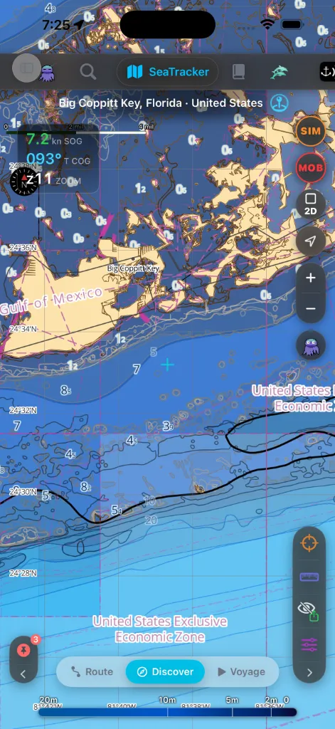
Löydä
Oletustila. Kartta on sinun vaeltaa.
mittarisi.
satamat, ankkuripaikat, vaarat, hylyt, valosektorit, AIS-alukset, meren eliöt,
sukelluskohteet, kalastusvahti, valtameridata, Wikipedia-artikkelit ja omat
kapteenin merkkisi.
näyttää syvyyden tähtäimen alla, kun panoroit.
eteenpäin katkoviivana — kätevää risteävälle liikenteelle. Se on taso, jonka
voit kytkeä (oletuksena päällä) kohdassa Karttatasot → Navigointi, jossa voit
myös asettaa sen värin ja viivatyylin.
Käytä Löydä-tilaa oppiaksesi alueen, tiedustellaksesi ankkuripaikan tai
selataksesi kiinnostavia kohteita.
Elävä mittarilukema
Jos olet yhdistänyt NMEA-mittarilähteen (Wi-Fi-yhdyskäytävän tai
Bluetooth-yksikön — katso [Asetukset → Ankkurivahti →
Mittarit](settings.html#anchor-watch)), GPS-HUD:iin kasvaa elävä mittariosio. Se
ilmestyy vain lähteen ollessa yhdistettynä; sisäänrakennetun GPS:n laitteessa HUD
on muuttumaton.
(keltainen) tai EI SIGNAALIA (punainen) — siirtotien (TCP / UDP / BLE) ja
kuinka kauan sitten viimeisin data saapui. Ikä jatkaa laskemista ylöspäin, jos
syöte hiljenee, joten jäätynyt "12 s sitten" on vihjeesi, että yhdyskäytävä
lakkasi lähettämästä.
veden mataloituessa), tuulen (näennäinen tai tosinopeus kulmineen) ja — kun
napautat korttia laajentaaksesi sen — keulasuunnan, vauhdin veden suhteen
ja meriveden lämpötilan. Vain ne arvot, joita mittarisi todella lähettävät,
ilmestyvät.
tuulelle, jotka vierittyvät uusien lukemien saapuessa, joten näet merenpohjan
mataloituvan tai tuulen voimistuvan yhdellä silmäyksellä.
Satelliitti- & hybridiperuskartta
Voit peittää korkearesoluutioista satelliittikuvastoa suoraan vektorimerikarttatasojesi
alle saadaksesi täydellisen valokuvallisen ja metrisen näkymän rannikkovesistä.
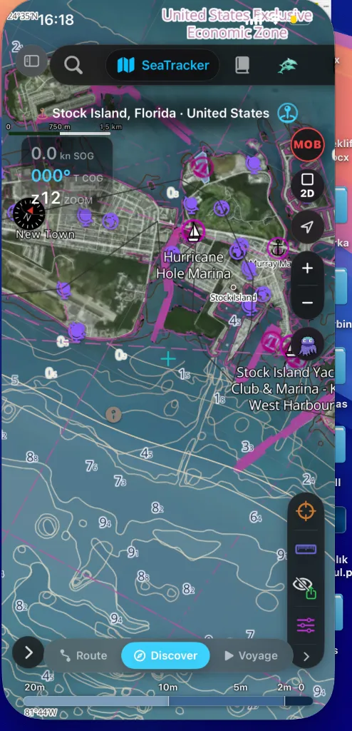
Ottaaksesi tämän käyttöön:
Tämä peittää korkean tarkkuuden syvyysluvut ja syvyysvaaralinjat suoraan
todellisten rannikkorakenteiden päälle, mikä tekee erittäin helpoksi suunnitella
tuloväyliä tuntemattomiin merisatamiin (kuten Hurricane Hole Marina Stock
Islandilla, Floridassa).
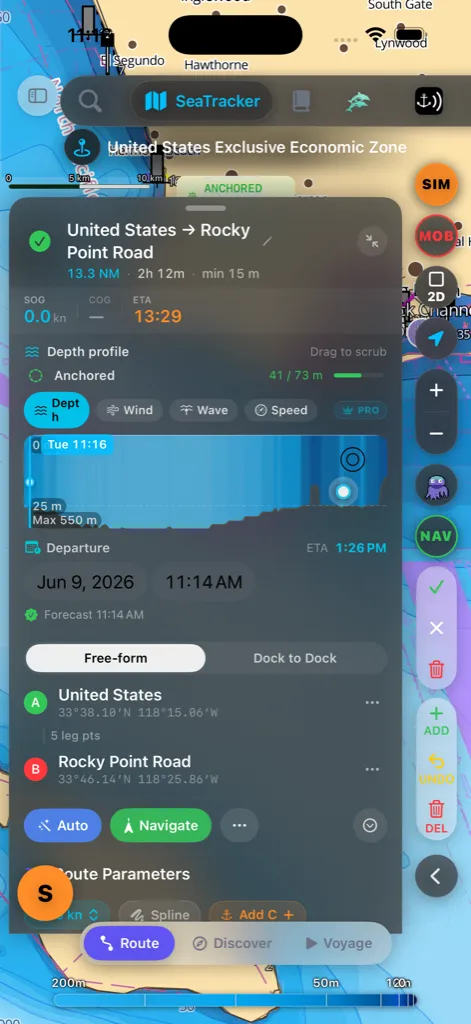
Reitti
Reittitila korvaa HUD:in Reittipaneelilla alhaalla.
"luo"- tai "OK"-vaihetta. Heti kun alku (A) ja loppu (B) ovat olemassa, sovellus
suunnittelee purjehduksesi automaattisesti matalikkojen ja maaesteiden ympäri
käyttäen suorituskykyistä Hybrid A*-APF (keinotekoinen potentiaalikenttä)
napauttamalla karttaa, pitämällä pohjassa tai käyttämällä ADD-painiketta.
napsahtaa kolmen korkeuden välillä — ohut kurkistus, puoliarkki ja
täysi — ja yksi yhtäjaksoinen veto vie kokonaan täyteen; sinun ei enää
tarvitse vetää kahdesti.
vedä sitä tarkastaaksesi minkä tahansa osuuden.
reunan säädinsarakkeeseen (lähennyspainikkeiden alle): ADD pudottaa
reittipisteen tähtäimeen (toinen ADD suunnittelee reitin automaattisesti),
UNDO poistaa viimeisen, DEL poistaa lähimmän. Vedä reittipistettä suoraan
kartalla siirtääksesi sen. Kapseli on vain vapaamuotoinen — se on piilossa
Telakasta telakkaan -tilassa, jossa rakennat reitin kahdesta telakkapaikasta
sen sijaan.
asetit — se ei napsahda veneesi nykyiseen sijaintiin. Käytä seuraa-painiketta,
jos haluat kameran seuraavan alustasi.
Hybrid A*-APF & relaksaatiokaskadi
Reitityskone toimii pääsäikeen ulkopuolella varmistaakseen ehdottoman liittymän
reagoivuuden ja ratkaisee polut kolmessa loogisessa vaiheessa:
polun, joka kunnioittaa aluksesi syväysrajoituksia ja turvamarginaaleja.
lukitut koordinaatit käyttäen esteiden hylkimisvektoreita. Maamassat ja
matalikot kohdistavat positiivisen potentiaalin (työntäen reitin pois), kun
taas määränpää kohdistaa negatiivisen potentiaalin (vetäen reitin sisään),
tuloksena puhtaita, luonnollisesti kaartuvia purjehduksia.
sataman lukko" -pulman (jossa reittiä ei voida suunnitella, koska aloitustelakka
tai määränpääpaikka on ohuessa vedessä), kone ajaa 3-tasoisen kaskadin:
* Tiukka tila: Pakottaa täyden syväyksen + turvavälin koko reitin
varrella.
* Matala tila: Jos Tiukka epäonnistuu, suunnittelija relaksoi
turvavälisäännöt päätepisteiden lähellä varoittaen samalla mahdollisesta
syväysaltistuksesta.
* Paras yritys -tila: Relaksoi turvavälirajat kokonaan telakoiden
lähellä taatakseen, että yhtäjaksoinen reitti syntyy, sen sijaan että se
keskeyttäisi reititysvirheellä.
Telakasta telakkaan
Reittipaneelin yläosassa kaksisuuntainen kytkin valitsee, miten rakennat reitin:
pudottaaksesi niin monta ankkuria kuin haluat; sovellus reitittää kunkin parin
välillä.
tuohon satamaan" -purjehdukselle.
Telakasta telakkaan -tilassa paneeli näyttää kaksi paikkaa:
Voit myös napauttaa sijaintikuvaketta käyttääksesi nykyistä sijaintiasi tai
lauttakuvaketta pudottaaksesi lähimpään satamaan.
asetettu. Heti kun valitset lähdön, määränpäävalitsin avautuu automaattisesti,
jotta voit hakea suoraan, minne olet menossa.
Valitsin luettelee merisatamat & satamat ensin, muut paikat alla, ja näyttää
etäisyyden nykyisestä näkymästäsi. Kun molemmat telakat on asetettu, sovellus
reitittää automaattisesti niiden välillä matalikkojen ympäri, aivan kuten
Vapaamuotoinen.
voit vahvistaa valinnan — lähtö (A) keskittää näkymän uudelleen aivan kuten
määränpää (B).
määränpään päinvastoin — reitti suunnitellaan uudelleen välittömästi.
Kapteenin kirjasto
Capt's Routes -kohta sivuvalikossa avaa Kapteenin kirjaston — yksi haettava
paikka hallita kaikkea, mitä olet tallentanut tai kerännyt:
yksityiskohtaeditorin; pyyhkäise poistaaksesi. Pidä pohjassa täyttä
toimintovalikkoa varten: Näytä kartalla, Aloita navigointi, Monista,
Käännä suunta, Vie GPX ja Purjehdussuunnitelma (PDF) — tulostettava
A4-purjehdussuunnitelma suoraan luettelosta, ilman yksityiskohta-arkkia.
nimeä, symbolia ja ankkuripaikan oleskeluaikaa; tähtäyspainike lentää kartan
siihen.
poistaaksesi.
kesto, jälkipisteet). Napauta yhtä täyttä purjehduslokia varten tilastoineen ja
ETA-laskimineen.
Hakulaatikko, lajitteluvalikko ja elävä tuloslukumäärä istuvat luettelon
yläpuolella. ⋯ Lisäasetukset -valikko lisää Tuo GPX ja Hallitse
kansioita.
Vaaka-asennossa kirjasto avautuu oikeassa yksityiskohtapaneelissa, jotta voit
hallita reittejä kartan pysyessä näkyvissä; pysty-asennossa se avautuu arkkina.
Purjehdus
Purjehdus on aktiivista navigointia. Yksi painallus-ja-pito muuttaa kartalla
olevan kohdan suunnitelluksi purjehdukseksi, jonka sitten valitset aloittaa.
Kunnes olet purjehtinut muutaman matkan, kartalla oleva vihje muistuttaa sinua
eleestä.
ympärille; pidä, kunnes se täydentyy.
reitittää nykyisestä sijainnistasi (A) kyseiseen pisteeseen (B)
matalikkojen ja maan ympäri. Napauta pillerin ✕ hylätäksesi suunnitelman.
Jos jokin estää reitin — ei GPS-paikannusta, määränpää maalla, piste liian
lähellä venettä — pilleri kertoo sen siinä paikassa.
arvioituine aikoineen, ja suunniteltu polku piirtyy kartalle
katkoviivaesikatseluna — panoroi ja lähennä vapaasti tarkastaaksesi sen.
tallennus (jälkesi, reittipisteiden saapumiset ja tilastot) alkavat, syvyys-
ja sääkaaviot täyttyvät, ja lähellä olevat karttakohteet putoavat molempiin
päihin. Napauta Hylkää hylätäksesi suunnitellun reitin; mitään ei aloiteta
eikä tallenneta.
Koska vahvistat Aloita-painikkeella, harhautunut pohjassapito ei koskaan
käynnistä purjehdusta itsekseen. Molemmat päätepisteet nimetään lähimmän paikkansa
mukaan. Jos vene on liikkunut merkittävästi kortin odottaessa, Aloita-painikkeen
napauttaminen suunnittelee hiljaa uudelleen siitä, missä todella olet, ennen kuin
navigointi alkaa, jotta reitti alkaa aina keulasta — ei siitä, missä se oli
muutama minuutti sitten.
Jo navigoimassa? Pohjassapito purjehduksen ollessa käynnissä ei aloita
uutta — se ehdottaa reittipisteen lisäämistä kyseiseen kohtaan ja reitittää
uudelleen nykyisestä sijainnistasi sen kautta, vahvistustasi odottaen.
Aktiivisen navigoinnin HUD
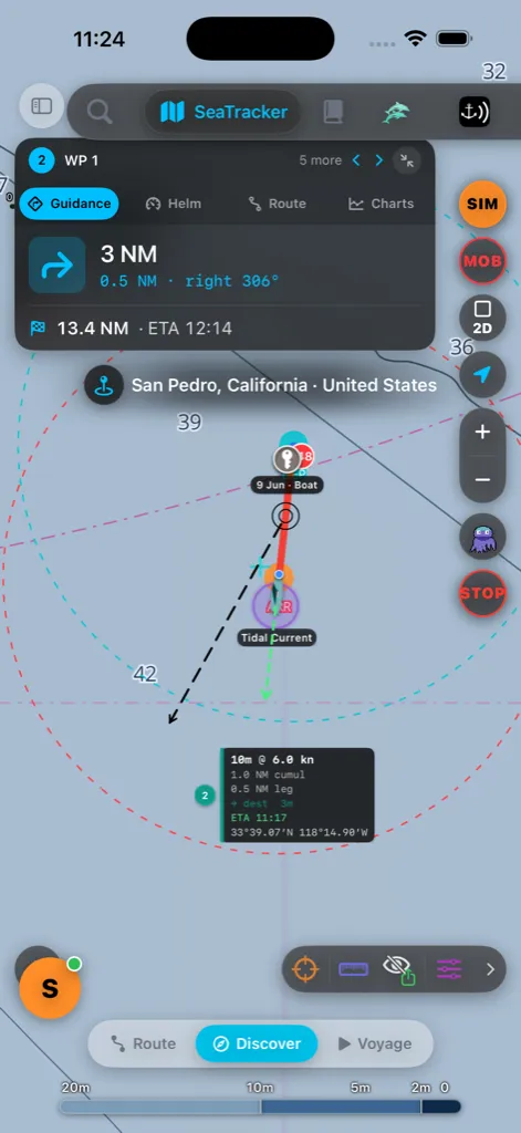
Navigoidessasi yksi kortti istuu kartan yläosassa neljällä napautuksella
vaihdettavalla osiolla:
poikkeamapalkilla reittiviivasta.
jäljellä oleva etäisyys ja sijaintisi reitillä.
tyyppipainikkeita vaihtaaksesi, mikä kaavio näytetään. Syvyys on aina
ilmainen; Tuuli-, Aalto- ja Vuorovesiennustekaaviot ovat
Pro-ominaisuus — ilmaistilillä nuo nauhat näyttävät lukitun "Pro-ominaisuus"
Tuuli piirtää puuskan haaleampana katkoviivana tuuliviivan päälle
tuulensuuntanuolineen. Jokainen kaavio näyttää elävän ennustedatan reitin
varrella, reittipistemerkit ja etäisyysasteikon. Valkoinen piste seuraa
nykyistä sijaintiasi; vedä kaaviota raapiaksesi valkoista pistettä reitin
varrella kartalla — se napsahtaa takaisin elävään sijaintiisi hetken kuluttua.
Vuorovesi näyttää ennustetun sataman vuorovesikorkeuden reittisi varrella,
piirrettynä keskimerenpinnan linjan ympärille (käyrä painuu linjan alle
matalalla vedellä); siellä missä vuorovesiennusteet eivät ole saatavilla
alueelle, kaavio näyttää aukon arvauksen sijaan.
Käytä HUD-otsikon ‹ › -nuolia astuaksesi edelliseen tai seuraavaan
reittipisteeseen; lyhyt palkki vahvistaa uuden kohteen. Pienennä-painike (⤡)
HUD-otsikossa tiivistää koko kortin pieneksi NAV · WP -pilleriksi; napauta
pilleriä tuodaksesi sen takaisin. Paikan nimen merkki sujahtaa suoraan HUD:in
alapuolelle, jotta loput kartasta pysyy selkeänä.
Komentoikkuna alhaalla (syvyysraapija + toistosäätimet) on kolmessa koossa —
napauta sen vaihepainiketta selataksesi täysi → tiivis → pienennetty ja
takaisin, vapauttaen karttatilaa, kun et tarvitse sitä.
Vaaka-asennossa HUD on leveysrajattu johtavalle puolelle, jotta se ei koskaan
syö karttaa, ja siitä avaamasi paneelit (reitin tiedot, purjehdussuunnitelma)
telakoituvat oikeaan yksityiskohtasarakkeeseen kartan peittämisen sijaan — sama
jakautumiskäyttäytyminen kuin [Kapteenin kirjastolla](#captains-library).
Pysäyttäminen & uudelleenreititys
lukee STOP navigoidessasi. Sen napauttaminen pyytää sinua vahvistamaan
ennen opastuksen lopettamista, jotta harhautunut napautus ei voi pudottaa
reittiäsi.
palkki liukuu esiin näyttäen ajan ja etäisyyden, jonka säästäisit. Napauta
Hyväksy uudelleenreititys vaihtaaksesi tai Pidä nykyinen — se myös
hylkää itsensä muutaman sekunnin kuluttua, jos et tee mitään.
Paikan etsiminen
Napauta hakukuvaketta yläpalkissa avataksesi hakupaneelin. Siinä on kaksi
välilehteä:
Mitä Karttahaku käy läpi
Yksi hakulaatikko hakee kaikkea kerralla ja ryhmittelee tulokset sen mukaan,
mistä ne tulivat, oma datasi ensin:
| Ryhmä | Mitä se löytää | Mistä se tulee |
|---|---|---|
| Kapteenin merkit | Tallennetut nastasi, sukelluskohteet ja tallennetut artikkelit | Laitteellasi |
| Reitit | Tallennetut reittisi (nimeltä) | Laitteellasi |
| Reittipisteet | Nimetyt reittipisteesi | Laitteellasi |
| AIS-alukset | Elävät lähellä olevat laivat nimeltä, MMSI:llä, kutsumerkillä, tyypillä tai määränpäällä | Elävä AIS-syöte |
| Satamat | Merisatamat ja satamat sisäänrakennetusta tietokannasta | Laitteellasi |
| Merimerkit | Kartoitetut poijut, viitat ja majakat | Laitteellasi |
| Paikat | Lahdet, saaret, kaupungit, maamerkit, osoitteet | OpenStreetMap (verkossa) |
| Paikat (Google) | Merisatamat, yritykset ja kiinnostavat kohteet nimeltä, missä saatavilla | Google Places (verkossa) |
| Satamat (verkossa) | Maailmanlaajuinen merisatama-/satamatietokanta — tuhansia merisatamia palveluineen, suojineen ja tulosyvyyksineen | OpenSeaMap (verkossa) |
| Tutkimukset | Wikipedia-artikkelit lähellä olevista paikoista | Wikipedia (verkossa) |
Oma datasi ja elävä AIS ilmestyvät välittömästi kirjoittaessasi.
Verkkoryhmät liittyvät hetkeä myöhemmin — ne alkavat, kun olet kirjoittanut kolme
kirjainta, ja sovellus odottaa lyhyttä taukoa kirjoituksessasi ennen yhteyden
ottamista, joten se ei laukaise pyyntöä jokaisella näppäinpainalluksella.
Verkkotulokset ovat välimuistissa, joten tuoreen haun toistaminen palauttaa
tulokset välittömästi ja toimii edelleen, kun myöhemmin siirryt verkottomaksi.
Tuloksen lukeminen
Jokainen rivi näyttää nimen, lyhyen alaotsikon (aluksen tiedot, reitin pituuden,
sataman palvelut ja niin edelleen) ja — kun sovellus tietää sijaintisi —
etäisyyden meripeninkulmissa. Pieni katkoviivaneliökuvake tarkoittaa, että
paikalla on tunnettu raja, joten siihen lentäminen rajaa koko alueen yksittäisen
pisteen sijaan.
Napauta tulosta (tai sen → -painiketta) lentääksesi kartan sinne ja
pudottaaksesi nastan kohtaan, merkittynä nimellään, jotta sijainti pysyy
merkittynä kameran asetuttua. Napauta nastaa poistaaksesi sen. Reittituloksen
napauttaminen paljastaa kyseisen reitin ja rajaa sen päästä päähän;
Wikipedia-tuloksen napauttaminen avaa myös sen artikkelipaneelin.
Tuoreet haut
Laatikon ollessa tyhjä paneeli näyttää Tuoreet-hakusi. Jokainen rivi kantaa
pientä merkkiä, joka näyttää, kuka sen ajoi:
etsimään jonnekin, hän hakee aivan samoja lähteitä kuin yllä luetellut, joten
merisatama, jonka hän löytää, päätyy tänne valmiina napautettavaksi.
Napauta ✦ Jules -pilleriä luettelon yläpuolella näyttääksesi vain Julesin
löytämät paikat. Tyhjennä historia pyyhkii tuoreiden luettelon ja
verkottomuusvälimuistin.
> Kaikki verkkolähteet eivät ole navigointiin ja saattavat olla
> käyttämättömissä ilman yhteyttä — karttasi, merkkisi, reittisi sekä
sisäänrakennettu satama- ja merimerkkidata toimivat aina verkottomana.
Karttatyylin valitseminen
Peruskarttatyyli ja syvyyspaletti sijaitsevat kartassa itsessään — avaa
Karttatasot-arkki oikeasta alakulmasta ja valitse ne Kartat-välilehdeltä
(katso [Karttatasot](#layers)). Valinta on yleinen ja säilyy käynnistysten yli;
uuden asennuksen oletukset (Nautica Day -peruskartta + käänteinen NOAA-paletti) on
viritetty päivänvalon selkeyteen ankkurissa. Ainoa karttaulkoasun säädin
kohdassa Asetukset on Sovita automaattisesti
laitteen ulkoasuun -kytkin, joka kääntää paletin päivä- ja yösisarustensa
välillä, kun iOS vaihtaa vaalean/tumman tilan — se ei valitse peruskarttaa.
Karttatasot-paneeli
Karttatasot-arkki on paikka, jossa jokainen peite kytketään päälle tai pois.
Se on järjestetty viiteen välilehteen yläosan poikki, jotta hyppäät suoraan
haluamaasi sen sijaan, että vierittäisit yhtä pitkää luetteloa:
tarjoajat), syvyyspalettiteema, Syvyys & batymetria -ryhmä (Syvyyskäyrät
ja Syvyyspolygonit ovat oletuksena päällä, jotta uusi asennus avautuu
luettavaan batymetriakarttaan; raskaampi Vesisyvyydet / EMODnet-täyttö pysyy
poissa, kunnes kytket sen päälle, ja karttateeman vaihtaminen näyttää käyrät ja
polygonit uudelleen, jos olit piilottanut ne) ja
vektoriperuskartan alitasot (tiet, rakennukset, nimet, POI:t, rajat). Aloita
tästä asettaaksesi, miltä kartta näyttää.
(merimerkit, rajat, merivyöhykkeet, [liikenteenjakojärjestelmät](#tss), tulli,
rasterikartat) ja verkoton S-57 ENC -pino, jonka avaat asentamalla alueen
(syvyysluvut, väylät, vaarat, merenpohja).
merimerkit, satamatietokanta, sää ja tutkimustasot (meren eliöt,
sukelluskohteet, kalastustoiminta, valtameridata).
AIS-API-syöte (aisstream.io / VesselAPI) tarjoaja- ja yhteystiloineen ja
Laivasto (etäsynkronointi) -ryhmä — kapteenit, jotka jakavat elävää sijaintia
SafeAnchor-etäkanavan kautta, lyhyellä yhteenvedolla, joka näyttää kanavan nimen
ja kuinka monta alusta on synkronoitu. Syöte alkaa joka käynnistyksellä
oletustarjoajalla aisstream.io; VesselAPI:a käytetään vain automaattisena
varajärjestelmänä (jos aisstream.io pysyy tavoittamattomissa) tai kun valitset
sen itse, ja kyseinen valinta kestää vain istunnon ajan — seuraava käynnistys
palaa aisstream.io:hon. Kun panoroit tai lähennät, jo näytöllä olevat laivat
pysyvät paikoillaan syötteen tilatessa uudelleen uudelle alueelle taustalla —
ne päivittyvät paikallaan vilkkumatta pois ja takaisin.
alaosaa muiden AnchorQueen-kapteenien eläville sijainneille, jotka lähettävät
julkisella majakkalähetyksellä lähellä katselemaasi paikkaa. Ne näkyvät
kartalla keltaisella renkaalla (jotta erotat heidät omasta laivueestasi,
joka on turkoosi, ja raa'asta AIS:stä, jolla ei ole rengasta) ja päivittyvät
elävästi lähennettynä. Lyhyt yhteenveto näyttää, kuinka monta on näkyvissä. Se
alkaa poissa, koska elävän syötteen auki pitäminen käyttää dataa — kytke se
päälle, kun haluat nähdä, kuka on ankkuroituneena vilkkaan lahden ympärille.
jäljet, napsautusviiva, ankkurihistoria) sekä ankkurivahtirenkaiden,
oman aluksen viivojen ja tilakohtaisten tähtäinvärien ulkoasu.
Salama-valikossa vasemmassa yläkulmassa on Näytä kaikki tasot ja
Piilota kaikki merimerkit -pikatoiminnot, tavoitettavissa miltä tahansa
välilehdeltä.
Liikenteenjakojärjestelmät (TSS)
Vilkkailla vesillä laivaliikenne ohjataan liikenteenjakojärjestelmien läpi —
yksisuuntaiset väylät vastakkaisille liikennevirroille, erotettuna
erotusvyöhykkeellä, jonka ulkopuolella sinun on pysyttävä. AnchorQueen kantaa
IMO/IHO-järjestelmädataa verkottomana ja piirtää sen kartalle; taso sijaitsee
kohdassa Karttatasot → Kartat (nav) ja on oletuksena päällä, koska
meriteiden säännöt (COLREGS sääntö 10) edellyttävät sinua
kohtelemaan näitä vyöhykkeitä huolellisesti.
Kartalla väylät näyttävät, mihin suuntaan liikenne kulkee; erotusvyöhyke
on nauha vastakkaisten väylien välissä.
Matkalla ollessasi AnchorQueen tarkkailee jälkeäsi minkä tahansa lähellä olevan
järjestelmän suhteen ja nostaa palkin:
mihin suuntaan väylä kulkee, ennen kuin sitoudut.
sanoo, että ylitä mahdollisimman lähellä suoraa kulmaa — oikaise kohti 90°.
kulkusuuntaa, sääntö 10:n rikkomus. Muuta suuntaa.
Palkki näytetään aina näytöllä hälytyksen ollessa elävä; käyttöjärjestelmän
ilmoitus lähetetään myös, kun sovellus on taustalla. Ankkurointi on
erikoistapaus — sääntö 10(g) kieltää sen erotusvyöhykkeen sisällä — ja sen
hoitaa ankkurivahti, katso
SafeAnchor → Ankkuroituneena erotusvyöhykkeellä.
Kytke hälytykset pois (taso jää) kohdassa
Asetukset → Nav → Turvahälytykset.
S-52-karttapiirto & paikalliset vektorikartat
Ytimessään AnchorQueen käyttää muunneltua MapLibre GL -vektorikäännöskonetta,
joka on suunniteltu tarjoamaan erittäin vuorovaikutteinen, 60 fps:n karttakokemus
täysin verkottomana.
* S-52 päivä- & yökartat: IHO:n (International Hydrographic Organization)
esityskirjastostandardeja noudattaen sovellus kääntää S-57 ENC -piirteiden
ominaisuudet (syvyyskäyrät, valosektorit, poijut, rajoitusalueet) dynaamisesti
käyttäen mukautettuja tyylittelytyylisivuja (Nautica Day ja Nautica
Night).
* Verkottomat vektori-MBTilet: Raaka batymetria, maan ääriviivat ja
meriraja-alueet käännetään optimoiduilla matemaattisilla yksinkertaistuksilla
(tippecanoe) erittäin tiivistetyiksi, paikallisiksi MBTile-paketeiksi
(adminland.mbtiles, maritimezones.mbtiles, admin_places.mbtiles). Tämä
vähentää pysyvän tallennustilan gigatavuista raakaa GeoJSONia muutamaan sataan
megatavuun, estäen muistinpuutekaatumiset mobiililaitteilla.
* Sisäänrakennetut SDF-glyfit: Täysin verkoton Signed Distance Field
(SDF) -fonttipaketti kattaa latinalaiset, kyrilliset, kreikkalaiset ja
turkkilaiset merkistöt, mahdollistaen reaaliaikaisen fonttipiirron millä
tahansa kallistus- ja lähennyskulmalla.
* Kölisyvyyshaut: Tähtäimen napauttaminen laukaisee paikallisen
tila-Kd-puuhaun kysyäkseen syvyyslukuja ja fyysisiä vaaroja kohdistimen alta.
Tämä toiminto suoritetaan pääsäikeen ulkopuolella estämään kartan nykiminen
nopeiden panorointien aikana.
Jäljen tallentaminen
Avaa Tallennusarkki kartan toimintovalikosta aloittaaksesi jäljen tallennuksen.
Jäljet tallennetaan GPX-tiedostoina, jotka voit pitää, jakaa tai toistaa
myöhemmin uudelleen kohdasta Capt's Notebook.
Verkottomat ruudut
Avaa Välimuistiarkki kartan toimintovalikosta ladataksesi ruutupaketin
purjehtimallesi alueelle. Kaupasta asennetulla alueella alueesta
tulee täysin verkottomuuskykyinen.
Jos jokin menee pieleen
olevia ruutuja tai asennettu vastaava alue. Katso Kauppa.
liian matalaa syväyksellesi; siirrä pistettä syvempään veteen ja yritä uudelleen.
uudelleen syvempään veteen.