In town for the Fort Lauderdale boat show? Stay a week.
South of Fort Lauderdale the coast changes character fast. Within a day’s sail you leave the high-rises behind for Biscayne Bay: shallow, clear water, a string of low mangrove keys, and a national park that is almost all sea. Another day or two and you reach Key Largo, where the reef line runs parallel to the shore and the water turns from green to blue.
This loop is not hard sailing, but it rewards planning. The bay is shallow, the cuts between bay and ocean are shallower, and the two open-water legs along the Atlantic coast depend on the wind and the Gulf Stream. Get the timing right and you have a week of short hops, quiet anchorages, lighthouses and reefs — and you are back at the dock you started from.
![[Route image: the full 7-day loop — Fort Lauderdale → Key Biscayne → Biscayne National Park → Key Largo → Fort Lauderdale]](/images/blog/fort-lauderdale-itinerary/overview-route.webp)
The route at a glance
You leave Fort Lauderdale through Port Everglades and run south outside to Key Biscayne. From there you go inside: down Biscayne Bay to the islands of Biscayne National Park, then through the Intracoastal Waterway (ICW) into Card Sound at the top of Key Largo. A short, shallow creek takes you out to Hawk Channel and the reefs of John Pennekamp Coral Reef State Park. The way home is a long day north up Hawk Channel to Key Biscayne and a last coastal hop back to Fort Lauderdale.
Distances are approximate, measured along a typical track for a 40-foot sailboat drawing about 5 feet at 6 knots. Your own track will differ.
| Quick facts | |
|---|---|
| Total distance | About 155 nm in seven legs, from 5 to 45 nm a day |
| Sailing time | About 26 hours at 6 knots |
| Best season | November to April, South Florida’s dry season. Hurricane season runs June 1 to November 30. |
| Difficulty | Intermediate: two coastal passages, shallow-water pilotage, one long day |
| Draft | The inside legs suit boats drawing about 5 feet or less |
| Air draft | The ICW through Miami has a fixed bridge of about 56 feet, so taller rigs run outside |
| Charts and notices | Current NOAA electronic charts, U.S. Coast Pilot 4, Local Notice to Mariners |
| Fees (checked October 2026) | Bill Baggs Cape Florida State Park $20 a night; Boca Chita and Elliott Key $60 a night docking and camping |
| Radio | Bridge tenders on VHF 9 |
Things to know
Depth and draft
This is skinny-water cruising. Much of Biscayne Bay and Card Sound is under about 12 feet deep, with grass flats and banks close to the marked channels. The NPS gives the Boca Chita harbor entrance as about four feet at low tide and Elliott Key harbor as about two and a half. Angelfish Creek, the cut from Card Sound to the ocean, has a reported controlling depth of about five feet. If you draw more than that, plan the Key Largo part of the trip from the ocean side and treat the bay stops as day visits by dinghy.
Bridges and inlets
Port Everglades is the deep, well-marked inlet and the one to use. On an ebb against an onshore swell, seas stack up at any inlet mouth, so time your exit and return with the tide. Inside, the Las Olas Bridge opens at quarter past and quarter to the hour, and the SE 17th Street bridge on the hour and half hour (top of the hour only at weekday rush hour) under current federal rules. Hail tenders on VHF 9. Heading south on the ICW, the Julia Tuttle Causeway bridge in Miami is fixed at about 56 feet, which is why most sailboats go outside.
Weather and season
The National Weather Service treats November to April as South Florida’s dry season. Cold fronts are the thing to watch: they bring a shift to the north and northwest, and wind against the north-flowing Gulf Stream — whose west wall can sit just a few miles offshore — builds short, steep seas. Plan the two coastal legs for a settled day between fronts. Hurricane season runs through November 30, so early-season trips need a closer eye on the tropics.
Anchoring rules and fees
State law keeps anchored boats 150 feet from marinas and ramps and 300 feet from a marked mooring field. Anchoring on coral is illegal along this coast: use the free public mooring buoys on the reefs, or anchor in clear sand. Biscayne National Park has no entrance fee, but its two island harbors charge for docking. Speed zones change often, and seasonal manatee limits tighten from November 15. The posted signs win. Fees and rules here were checked in October 2026; confirm them before you go.
Day 1: Fort Lauderdale to Cape Florida (Key Biscayne)
Leg: Lake Sylvia → Port Everglades → Cape Florida · about 30 nm · outside
Spend the night before in Lake Sylvia, the round, sheltered basin just off the ICW south of the Las Olas Bridge (around ICW mile 1064.5). Guides describe entering near green “13” along the east side and anchoring in roughly 7–9 feet. It has no shore access and gets busy on weekend afternoons, but it puts you a short motor from the SE 17th Street bridge and the inlet.
Out through Port Everglades, keep clear of ship traffic and turn south a mile or two off the beach. With the wind in the east it is an easy run past Hollywood, Miami Beach and Government Cut. Enter Biscayne Bay around Cape Florida through one of the marked channels south of Key Biscayne; both carry shoal patches, so check the latest chart and notices before you commit.
Cape Florida (Bill Baggs Cape Florida State Park) has a small, well-protected basin on the bay side of the park. Cruising guides report roughly 5–8 feet inside. Overnight anchoring is $20 per boat, paid at honor stations on the seawall (cash or check) or by card at the ranger station during park hours. Boats may not tie to the seawall between 11 pm and 8 am, and no more than two may raft together. There is a free pump-out.
Ashore: walk across to the 1825 Cape Florida Lighthouse, the park’s landmark, and the beach on the ocean side. The park runs guided lighthouse tours; check the schedule when you arrive.
Food: Boater’s Grill, on the harbor itself, serves lunch and dinner.
Local tip: the harbor fills up on weekends. Arrive early in the afternoon if you can.
![[Route image: Day 1 — Lake Sylvia → Port Everglades → Cape Florida]](/images/blog/fort-lauderdale-itinerary/day-1-route.webp)
Day 2: Cape Florida to Boca Chita Key
Leg: Cape Florida → Featherbed Bank → Boca Chita Key · about 11 nm · Biscayne Bay
Leaving the harbor you pass Stiltsville, the handful of houses on stilts standing on the flats south of Cape Florida. The first shack went up in the 1930s. The site is now part of Biscayne National Park, and the houses can be visited only with a permit, so enjoy them from the water. Head south down the bay and cross Featherbed Bank in the marked channel. The banks on either side are shallow.
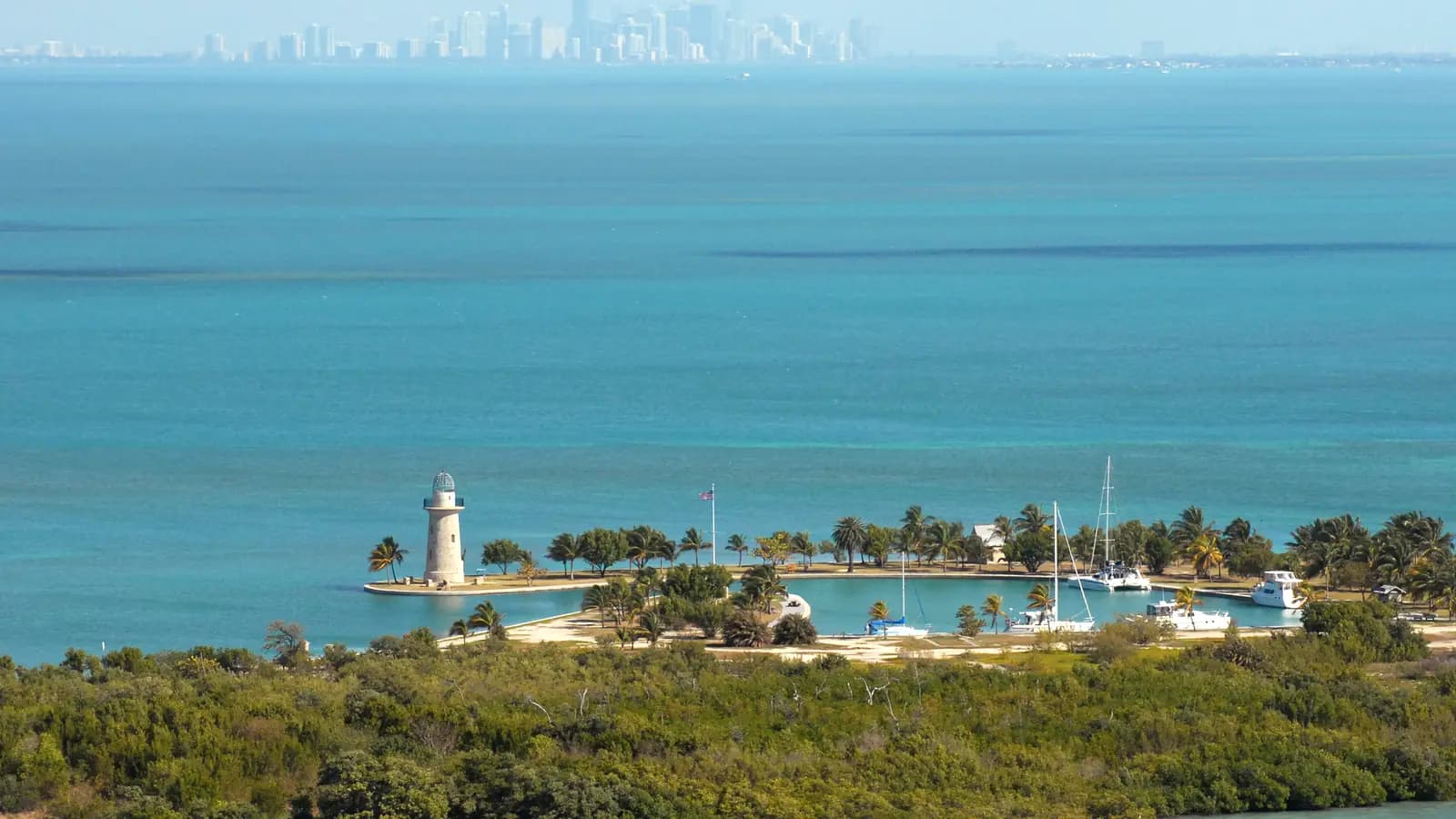
Boca Chita Key is the park’s most visited island, and you can see why as you come in: a neat harbor, a grassy lawn and a 65-foot ornamental lighthouse built by Mark Honeywell in the 1930s. The harbor entrance is about four feet at low tide (the NPS times low tide here at about 1 hour 43 minutes after Government Cut). Dock only along the cleated bulkhead, rafted no more than two deep. Overnight docking and camping is $60 a night, paid on arrival through the Recreation.gov app; download it before you leave, as the signal on the island is weak. There are no reservations. A $25 day-use fee applies Friday to Monday and on federal holidays.
Anchor: anchoring is not allowed in the harbor, in the slow-speed zone at its entrance or within 100 feet of the key. Deeper boats can anchor off in the bay and come in by dinghy.
Ashore: if a ranger is on the island, the lighthouse observation deck may be open, with a view across the bay to the Miami skyline. A half-mile trail loops to the south end of the key.
Local tip: pets are not allowed on Boca Chita, even aboard boats docked in the harbor. There is no drinking water and no trash collection, so bring what you need and take everything back.
![[Route image: Day 2 — Cape Florida → Stiltsville → Featherbed Bank → Boca Chita Key]](/images/blog/fort-lauderdale-itinerary/day-2-route.webp)
Day 3: Boca Chita Key to Elliott Key
Leg: Boca Chita Key → Sands Key → Elliott Key · about 5 nm · Biscayne Bay
A short hop, and a slow day. Elliott Key is the park’s largest island, once home to pioneers who farmed pineapples, harvested sponges and salvaged wrecks. Today it has a campground, picnic areas and trails through tropical hardwood hammock.
The harbor has 33 slips but only about two and a half feet at low tide (around 3 hours 25 minutes after Government Cut), so most keelboats anchor off the west side of the key in settled easterly weather and take the dinghy in. Fees match Boca Chita: $60 a night to dock and camp, $25 day use Friday to Monday. Restrooms, cold showers and drinking water are available, though the park advises bringing your own water in case the system is down.
Ashore: walk the trail, swim off the boat, and watch the light change over the bay in the evening. Pets on a leash are allowed in the developed areas here.
Local tip: mosquitoes and no-see-ums are around all year, so screens and repellent help. The west-side anchorage is open to the west; if a front is forecast, move before it arrives.
Shallow-draft option: further south, Caesar Creek and the anchorage by Adams Key are popular with small boats, but the creek entrances are reported at only about four feet at low water. Go only with a shallow boat and local knowledge.
![[Route image: Day 3 — Boca Chita Key → Sands Key → Elliott Key anchorage]](/images/blog/fort-lauderdale-itinerary/day-3-route.webp)
Day 4: Elliott Key to Pumpkin Key
Leg: Elliott Key → Cutter Bank cut → Card Sound → Pumpkin Key · about 10 nm · ICW
Follow the ICW south out of Biscayne Bay. It leaves the bay through a dredged cut across Cutter Bank and enters Card Sound, which the Coast Pilot describes as about five miles long with 7 to 12 feet in the middle. Pumpkin Key sits on the east side of the sound, close to the north end of Key Largo.
Anchor: guides list 7–9 feet off the south and west sides of the key, in sand and grass. Holding is generally good once you are set, but the grass can foul an anchor, so back down firmly and check it. The anchorage is open to the northwest through southwest.
Ashore: none. Pumpkin Key is private and clearly marked, and so is the neighbouring Ocean Reef community. This is a swim-and-sundowner stop.
Local tip: reviewers suggest staying on the west side of the key to avoid wakes from traffic along the mainland shore.
![[Route image: Day 4 — Elliott Key → Cutter Bank cut → Card Sound → Pumpkin Key]](/images/blog/fort-lauderdale-itinerary/day-4-route.webp)
Day 5: Angelfish Creek and the Key Largo reefs
Leg: Pumpkin Key → Angelfish Creek → Key Largo Dry Rocks → Rodriguez Key · about 25 nm · Hawk Channel
Angelfish Creek takes you from Card Sound out to the ocean. It is marked with lights and daybeacons, and its reported controlling depth is about five feet, so go near high tide and watch the depth sounder. Once out, turn south into Hawk Channel, the marked route between the keys and the reef line.
Off Key Largo you are in John Pennekamp Coral Reef State Park, the country’s first undersea park, which covers about 70 square nautical miles. At Key Largo Dry Rocks, a nine-foot bronze statue known as Christ of the Deep stands in a sand channel in less than 25 feet of water. Mooring buoys ring the reef. NOAA asks boats to go around the outside of the buoys rather than cut across the shallow reef to reach them.
Moor: the white buoys with a blue stripe are free, first come, first served and meant for short daytime stops, not overnight. Approach from downwind, pass your own bow line through the pickup eye and let out some scope. Fly a dive flag when people are in the water; other boats are expected to keep their distance.
Anchor for the night: Rodriguez Key, a few miles south. Guides report about 8–9 feet over sand with good holding. Reviewers describe it as a fair-weather anchorage that works well in easterlies and gets rolly when the wind goes north or northwest.
Local tip: do not anchor on coral anywhere along this coast. Florida law protects the reef, and the fines are real.
![[Route image: Day 5 — Pumpkin Key → Angelfish Creek → Key Largo Dry Rocks → Rodriguez Key]](/images/blog/fort-lauderdale-itinerary/day-5-route.webp)
Day 6: Rodriguez Key back to Key Biscayne
Leg: Rodriguez Key → Hawk Channel → Fowey Rocks → Cape Florida · about 45 nm · Hawk Channel and outside
This is the long day, so start at first light. Run north up Hawk Channel with the reef to starboard, past Carysfort and Pacific Reefs and on toward Fowey Rocks. In an easterly breeze it is a fine reach. If a front is forecast, this is the leg to move earlier or later in the week.
Come back into Biscayne Bay by the channels south of Key Biscayne. You pass Stiltsville again on the way in, before you return to Cape Florida (Bill Baggs Cape Florida State Park) for the night.
Food: a second visit to Boater’s Grill is easy to justify after a long day.
Shallow-draft option: with local knowledge and the right tide, smaller boats can come back inside through Angelfish Creek and up the bay, splitting this leg with a night at Elliott Key or Boca Chita.
![[Route image: Day 6 — Rodriguez Key → Hawk Channel → Fowey Rocks → Cape Florida]](/images/blog/fort-lauderdale-itinerary/day-6-route.webp)
Day 7: Back to Fort Lauderdale
Leg: Cape Florida → Port Everglades → Lake Sylvia · about 30 nm · outside
The last leg retraces the first: out around Cape Florida and north along the coast. Time your arrival at Port Everglades for a fair tide, avoid an ebb against an onshore swell, and allow for the SE 17th Street bridge schedule if you are heading back up the ICW. Hail the tender on VHF 9.
If you plan another night at anchor, older guides quote a 24-hour limit in Fort Lauderdale; the city rewrote its ordinance in 2025 around long overnight stays. Check current FWC and city rules before you drop the hook.
![[Route image: Day 7 — Cape Florida → Port Everglades → Lake Sylvia]](/images/blog/fort-lauderdale-itinerary/day-7-route.webp)
Planning it in AnchorQueen
On the web, see what the US East Coast and ICW charts cover, or how anchor watch works.
A short safety note
AnchorQueen is a planning and situational-awareness aid. It does not replace NOAA charts, the Coast Pilot, Local Notices to Mariners, posted signs, your instruments or your own seamanship. Depths in this area change, and the figures here are reported or approximate. Fees, rules and bridge schedules were checked in October 2026 and can change, so confirm them before you cast off.